ContentsKhami Ruins.
Dhlo Dhlo.
Naletale Ruins.
Old Bulawayo and the Jesuit Mission.
Indaba Tree, Government House.
Rhodes' Hut, Government House.
Whiteman's Camp.
The Pioneer Well.
Fort Umlugulu.
Diana's Pool.
Mangwe.
Hillside Dams.
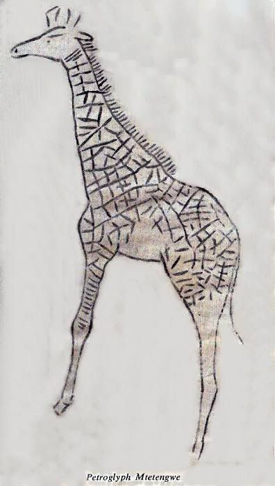
Mtetengwe Giraffe.
Pioneer Road Crossing.
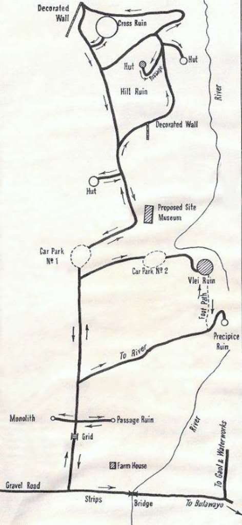
Khami RuinsThe Khami group of ruins is situated thirteen miles west of Bulawayo. The tourist should leave Bulawayo by Eleventh Avenue and follow the full tarmac road.
This complex of ruins belongs generally to me same period as Zimbabwe. The method of stone building, the presence of passages, platforms and free standing walls around enclosures show that there is indeed a very close relationship. The associated cultural material is generally very similar to that at Zimbabwe, Dhlo Dhlo and other ruined structures. But some variation can be found because a local preference can always be expected.
The name Khami was not the original name of the ruins but is the name of the river. Local Africans refer to the ruins as "Zimbabgwi", which is probably a corruption of the Karanga
Dzimba we bagwe — houses of stone — or Tangala which means walls. Local Makalanga tribesmen often refer to the whole area as
Madhladhla, the name of one who is said to have been the last
Mambo (ruler) at Khami.
Archaeological Investigations. The first examinations carried out were by seekers after gold and other valuable relics. W. G. Neal and G. Johnson removed a considerable amount of material during 1897. These people were followed by R. N. Hall who did clearing and digging from 1900 to 1910. and later produced the first guide book to the ruins. This has been so long out of print that it is now becoming rare Rhodesiana.
As early as 1900 Franklin White, a surveyor became interested in the ruins and published several papers in the journal of the Rhodesian Scientific Association. These papers included accurate descriptions and plans. He was also the first to report the presence of Stone Age artefacts in the gravels used for infilling the hut platforms.
There was very much speculation at this time about the age of the ruins, the romanticists conjuring up pictures of the Queen of Sheba and King Solomon's Mines, whilst the saner observers including Franklin White thought that they were much later and probably of African origin.
During 1905 the Rhodes Trust sponsored a visit by Dr. Randall MacIver to enable him to assess the age and importance of Rhodesian Ruins from the archaeological point of view. He examined a number of ruins including Khami. The results of his work were published in a book which he named Mediaeval Rhodesia. The name indicates the date which he suggested for the building period of the 16th-17th Century, A.D., a date which has been proved much nearer the mark than those of a more romantic nature.
R. N. Hall considered that there was evidence which indicated a date as early as A.D. 915.
This difference of opinion sparked off rows and arguments which befogged the issue for many years. The only point on which they agreed was that the ruins were of African origin.
Miss G. Caton-Thompson was invited by the Southern Rhodesian Government during 1929 to carry out further investigations into the history of the Rhodesian ruins. Although she did not do any work at Khami her investigations at Zimbabwe. Dhlo Dhlo and other ruins forced her to agree generally with the findings of Dr. MacIver.
During 1947 investigations carried out by Mr. K. R. Robinson. Chief Inspector of the Historical Monuments Commission, on the Hill Ruin confirmed that the findings of MacIver were substantially correct. A date in the 17th Century seems highly probable.
Prior to the start of the wall building other iron using people occupied the area, making pottery which differs very considerably from that made by the builders of the now ruined structures. The Ruins. The Khami Ruins cover an enormous area of country, but none of the buildings compare in size with the massive structures at Zimbabwe.
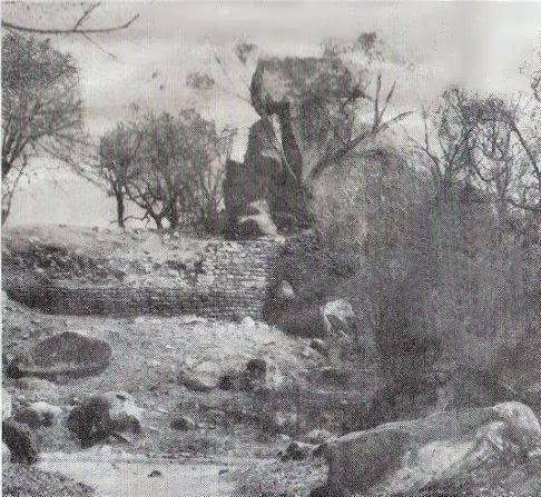 The Passage Ruin.
 After driving through the Khami Farm and soon after crossing a grid a large monolith will be seen on the left-hand side of the road. Park your car in this vicinity, and examine the stone work of a curved retaining wall which encompasses the bottom of the monolith. There is little else worthy of note in this small ruin, so take the path to the Passage Ruin which will be seen leading off on the right hand side of the road.
This ruin is built on a granite eminence and is roughly circular in plan. The passage leading through two well built walls is actually between two artificially built platforms on which were built the huts of the former occupants. The remains of huts can be seen on the top of the left hand one. The passage which is 47 feet long leads to both platforms and also to a kraal-like structure at the rear.
This little ruin appears to be a complete family unit, having the living quarters on the platforms and the housing for domesticated animals behind them. This could be the residence of an important man, but probably not that of the head of the ruling clan.
The Hill Ruin. This ruin is undoubtedly the most important. It is situated on the highest point in the immediate area and it overlooks the rocky gorge of the Khami River. Prior to the building of the dam wall by the Bulawayo City Council, large sand banks lined this gorge. It was possible to collect bangles and anklets made of copper or iron from these sands. These were probably the only visual remains of water carriers caught by the ever watchful crocodiles which inhabited the large pools up to a few years ago.
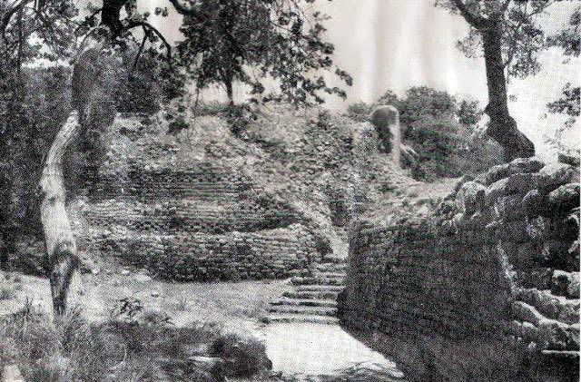
The hill should be approached from the car park following the direction notices. Once the fence has been passed, the visitor should examine the hill in front. It will be seen that there are three artificially built platforms lying like giant steps, one above the other. An immense labour was undertaken in carrying gravel from the valley in baskets or pots to infill the retaining walls for hut platforms. This was a task undertaken over a long period for there is evidence that the platforms were enlarged and heightened on a number of occasions.
Take the turning to the right towards the well built wall decorated with chequer pattern. An examination of this wall will show the observer that the blocks used for construction were roughly triangular or rectangular in shape, varying from six inches to one foot in length and from three inches to six inches in thickness. Most of these blocks have been dressed by blows with a stone hammer, the dressed side being the one facing outwards in most cases, although some blocks were dressed on more than one face.
The blocks were not quarried in the strict sense of the word, but were broken off exfoliated slabs caused by onion skin peeling of the granite. Fire and water were used as an aid to the breaking up of the flat exfoliated slabs.
Continuing up the footpath the visitor will pass two roughly cone-shaped rocks which are linked together by a short piece of decorated walling. A well beaten platform is immediately in front of this wall. Native legend has it that the path below was the way by which the Mambo's (Chiefs) cattle were driven up to the kraal. This platform was one of the places from which he could see them pass and no doubt count them.
Returning to the main path, modern steps will have to be negotiated until a level area bounded by a magnificent dry stone wall is reached. Undoubtedly one of the finest examples of walling at Khami.
The platform above this wall can be reached after climbing the next flight of steps. Remains of hut walls and floors can be seen on this flat area. The presence of these hut remains illustrates how the builders constructed a platform on which to live high up on the hill so that they could overlook the countryside.
Returning to the footpath it will be noticed that a stepped passage leads upwards towards the top of the hill. The total length of this passage is 141 feet. Walking up the passage it will be noted that all the wall stones have been cracked by heat. This is evidence of a destruction period when in all probability the passage roof was pushed in, the passage filled with brushwood and set alight. The prevailing south east wind blowing up the passage would have created ideal condition to generate enormous heat.
The passage widens out to an area about five feet wide. This was roofed and overlooks the same path which was mentioned earlier as the cattle path. Excavations in this area unearthed highly decorated pottery and a beautiful beaker which was undoubtedly a beer container. Many post holes in the floor furnished evidence far a substantial roof.
The passage takes a right angled turn and narrows down immediately after this point. The charred remains of posts which must have supported a daga roof line both sides. A semi-circular chamber opens off the right hand wall; the stone work forming the inside walls was completely covered with mud plaster which was returned over the top of the ledge which can be seen about four feet six inches above the floor. On this ledge were found the charred stumps of the roof timbers. If the visitor looks towards the top of the platform above, steps leading into mid-air may be seen. These undoubtedly led onto the flat roof of the passage and chamber.
Finally the passage leads through a narrow gap in a mud wall into a peculiar shaped hut; to all intents and purposes the passage continues through the hut, flanked by a low curb which undoubtedly supported the poles of a grass screen. Evidence of roof daga and supports was recovered from the hut showing the necessity for the very massive walls.
On leaving the hut turn to the right. Steps leading on to the roof are still to be seen.
Divining bones and other paraphernalia used by a witch doctor were found during the excavations. These may be seen in the National Museum, Bulawayo.
One can only conjecture why this passage was roofed and why it was very obviously a secret way up the hill. Offerings were probably left in the niche at the bottom and the supplicant was lead through this dark and noisome passage to the anteroom half-way up. From there he was probably taken into the presence of the witch doctor. No doubt depending on the value of the gifts either a favourable or unfavourable reply would be given. Often people disappearing into what was virtually a hole in the hillside never returned. The bangles found in the crocodile pool might well have belonged to some of these victims of savagery.
The remains of six huts can be seen on the platform reached from the passage. These probably represent the living quarters of the Chief, his wives and councillors. It is possible that the witch doctor lived in the hut within the passage, rarely if ever being seen except in semi-darkness.
During 1914 two schoolboys found a pot in the shape of a bull which had one leg missing. This pot is in the National Museum, Bulawayo. Because of its unusual character, the museum officials of that time were not completely satisfied of its true origins but kept it in the collections. There is a legend amongst local tribesmen that a bull used to be beaten with a whip during rain making ceremonies on top of the hill.
During excavations undertaken on behalf of the Historical Monuments Commission. Mr. Robinson unearthed a pot leg which fitted exactly the broken pot in the National Museum. At the same time he uncovered the metal bindings of a whip. Thus by archaeological investigations were the schoolboys vindicated and the legend proved to be correct, the pot being the symbolic model used in the ceremonies.
There are two routes down the hill, one which leads from the north-west side of the hill down to the same path which is over looked by the passage. The other is in the north-east corner. This leads down towards the river and was probably the route used to carry water up and by those throwing the accumulated rubbish away. The massive buttress wall built in cyclopean masonry was apparently built very hurriedly to prevent the terraced walls from further collapse.
The visitor should now follow the path. This will lead to a highly decorated wall 70 feet in length. The decoration consists of chequer pattern surmounted by courses of blackish-green diorite. It is known that three feet of herring-bone pattern existed above the dolorite courses before 1900.
The squared entrance may have been originally lintelled. This leads into an enclosure which was completely dug up by treasure seekers and now bears little resemblance to the original appearance.
The Cross Ruin. This nearly circular ruin is situated nearly north of the Hill Ruin and can be reached by following the path and notices. A flight of modern steps leads to a rock on which there is a cross made of granite blocks. The original cross is said to have been placed there by Portuguese missionaries some centuries ago. The cross was cemented in position in 1938. the original stones being used. The path then leads back to the entrance through which you came, but before leaving, turn up to the left and examine the remains of a hut on top of a granite exposure. This hut is thought to be the place in which bodies were desiccated by fire and smoke before burial. Legend has it that the corpses were smoked until completely dry. they were then wrapped in skins and thrown away.
Return to the car park and drive to car park No. 2 which is near the river and makes a pleasant spot in which to picnic. It is only a short walk from here to a turnstile leading into the Vlei Ruin. This little ruin is remarkable for the fact that it has free standing walls forming two compartments. These may have been cattle or small stock kraals. A walk of about half a mile from here will bring you to a low kopje over-looking the reservoir which supplies part of the water for domestic consumption in Bulawayo. On this hill you will see the Precipice Ruins, when this reservoir is full the ruin is surrounded on three sides by water. When occupied it was on a natural prominence overlooking the river.
The decorated retaining wall is probably the most massive and the longest of its type in the country, being 70 yards long and over 20 feet in height. There are three breaches in this wall probably made by the raiders pushing over huts during the destruction period.
There is a squared entrance at the north-west end of the ruin which gives access into a walled enclosure. There is no walling on the east side of the platform because the granite cliffs drop precipitously into the river valley below. This is said to have been the place of tribal ceremonies of a public nature.
History of the Ruins. Who, why and when? arc the questions that the visitor would like to be answered. Some have been partially dealt with in the first chapter, but they will be more fully dealt with under this heading.
Who were the builders? Everything points to a purely African origin for this style of building. They were occupied by a tribe practising a culture very similar to that of certain modern African peoples. This tribe is referred to by local tribesmen as the Rozwi. The Venda people of the Northern Transvaal claim kinship with the Rozwi. They were building in stone up to a very recent date; they wear anklets of wire and beads similar to those recovered by Miss Caton-Thompson from Dhlo Dhlo. Khami is said to have been founded by Changamire, a Rozwi chief who founded the
Mambo dynasty and destroyed the power of the Monomotapa empire towards the end of the 17th Century. The pottery tradition of the Venda resembles in many ways that found at Khami.
Why did they build? There has always been a desire by humans to live on hills, firstly because they are good lookouts and secondly because they are usually defensible. But there is a third reason, that of prestige, which is even important today, the best suburbs being usually situated on or near the top of the eminences around a town.
Generally speaking the ruins are not places of defence but represent prestige building, the highest being looked up at by the menials. The building of walled platforms for huts developed because no suitable flat areas existed on high places in the granite areas. The necessity for mystery and concealment from the ordinary people would have developed the grass screen, which was in some instances replaced later by the stone lined and roofed passages.
When were they occupied? By inference it is obvious that the Khami Ruins belong to the general complex of ruined stone buildings to be found all over Rhodesia. By scientific methods it has been shown that the phase represented at Khami dates from the 17th Century, A.D. onwards. The occupation was from then until the buildings were sacked and fired by impis from the south during the first one or two decades of the 19th Century, A.D. They have never been occupied since that date, but were preserved and used as a place for rain-making by Lobengula. Pre-Occupation maps show the Khami area marked as the King's Preserve. Lobengula. King of the Matabele kept a guard on the area and it was not until after his death that the ruins became known to the outside world.
ROUTES TO OTHER SITES OF INTEREST IN MATABELELAND
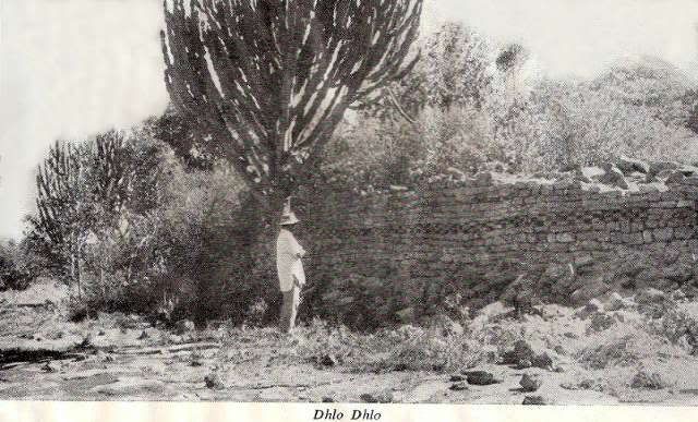
Dhlo DhloThe very interesting Dhlo Dhlo ruins are situated on a granite outcrop not far from Fort Rixon. To get there leave Bulawayo by the main Salisbury road; thirty miles from Bulawayo there is a sign post indicating the way. The road from this point is a well maintained gravel road which takes the motorist through open well watered grassland. After 20 miles a fork is reached soon after crossing a concrete drift over a small river. The ruins arc situated seven miles along the left hand fork. Excavations at these ruins revealed the relics of a Portuguese outpost; the silver chalice, a priest's private seal, a bell and portions of a bronze bowl being among the items recovered.
These are evidence that Dhlo Dhlo was the possible site of one of the places where Portuguese prisoners were kept by
Mambo during the 16th and 17th Centuries, A.D.
Early treasure seekers exploited this ruin, regarding the little city as a gold mine. They pillaged gold beads, gold wire and other manufactured and raw gold.
Portuguese relics are not so abundant in Rhodesia as might be expected, but here were found two cannon as well as the ecclesiastical relics.
The cannon are not necessarily evidence that the lull was a Portuguese Fort because early records state that arms and ammunition were supplied to friendly Africans to aid them in their wars with hostile neighbours.
There is a legend about Dhlo Dhlo which records that Swazi invaders captured the ruling Mambo there and skinned him alive as an example to his followers. This happened during the same period that saw the destruction of Khami.
The walls are well decorated with patterns and by the use or stones of contrasting colours.
Dhlo Dhlo is a very pleasant place and is an ideal spot for a picnic in the shade after a delightful drive.
On the return journey, about a mile beyond the Fort Rixon Club, is a notice board on the left hand side of the road which directs the visitor to the Pioneer Cemetery and the Fort which was built after massacres had taken place in the district during the early days of the Matabele Rebellion. It was maintained as a strong point for some years afterwards.
At the turn-off to White's Run Farm. 21 miles from Bulawayo. are plaques in English and Ndebele recording the battle and the great bravery of the Matabele soldiers who fought in what was to be the decisive battle of the Matabele War on November 1, 1893.
A direction sign indicates the way to the remains of the laager. It was to this laager that trooper White had to run to seek shelter when he was surprised by a party of Matabele warriors. He regained the security of the camp, but his companion and his horse were killed.
An alternative route is indicated on the map which can be taken if a change of scenery is desired, but it is longer.
 Naletale Ruins
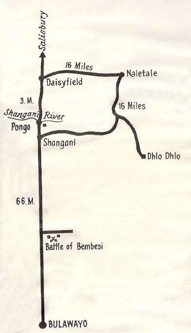
Take the Salisbury road from Bulawayo as far as Daisyfield, 69 miles from the City, where a well signposted road turns to the right. Sixteen miles from this point you will come to the farm buildings of Mr. Kirstein's Farm. A walk of three-quarters of a mile through a pleasant tree-lined glade will take you to the top of the kopje on which stands the ruined stone building known as Naletale.
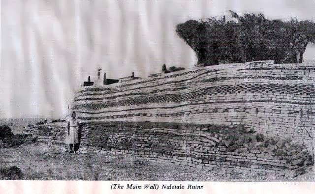
The building consists of an elliptical wall about 150 feet diameter, the outer portion of which has chevron, herring-bone, cord and chequer patterns as well as a variety of coloured stone inserts. This is undoubtedly the most magnificent decorated wall in Rhodesia.
The cubical structures on top of the main wall are part of the original building, but because of vandalism, it was essential to cement them in position before they were completely destroyed. A similar structure on the left hand side of the entrance still has some of the original mud plaster adhering to it.
The beauty of the site is enhanced by the strange shaped cabbage trees (Cussonia sp) and the aloes (A. chabaudii and A. aculeata) which grow out of the walls.
From the archaeological evidence it appears that the ruins were never completed and were constructed very late in the wall building period.
Dhlo Dhlo ruins may be seen on a clear day, with the aid of binoculars some 16 miles to the cast.
An alternative route is shown on the map returning via Shangani. This way is badly signposted and should only be taken if local directions can be obtained.
Either on the way out or on the return journey to Bulawayo a stop near the Shangani River bridge should be made. Near to this river on an old strip-road is a memorial recording the names of people who died in the Pongo Reserve during the unhappy days of the Matabele Rebellion of 1896.
Old Bulawayo and the Jesuit MissionA very pleasant short drive if one has a few hours to spare is to the site of the Jesuit Mission at Old Bulawayo. Take theroad past the Show Grounds leaving the turn-off to the Matopos on your right. Turn to the right at the sign past marked Criterion Road. Three and three-quarter miles along this road you will see an indicating sign directing you to the Mission. A walk of a few hundred yards will bring you to the remains of one of the oldest European built houses in Rhodesia.
The Jesuit Fathers reached old Bulawayo early in September, 1879, and were received by Lobengula, eventually obtaining permission to stay in the country and establish a Mission.
A Mr. Griete had established a store and trading post some time before this. He sold his store and his house to the Jesuits for £500 a great deal of money in those days.
Father Croonenberg wrote in his diary: "We have just bought for £500 sterling, an excellent house: it is one of the best in Gubuluwayo, though, to tell the truth, that is not saying much".
"Our enclosure, fenced with hedges, contains a large one-storey cottage, constructed in stone, like the small farm houses in the district of Namur; there are also some sheds and stables made of wood and pise; in addition there is a large store made of sheet iron. We propose to turn this into a chapel: it could hold 200 people with case. Wc also have a garden and poultry yard."
Unfortunately their hopes for converts were not fulfilled.
Priests of the Society of Jesus lived here and entertained Lobengula to tea in the centre room of this little cottage.
On June 21, 1885, Father Kroot died on the mission station. He lies buried in a small enclosure 200 yards from the house. Next to Father Kroot's grave is that of an African leper who accepted the Catholic Faith, in which he was confirmed.
During August-September, 1881, Lobengula transferred his kraal to the present site of Government House, Bulawayo.
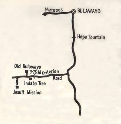 Monuments near Bulawayo
When Lobengula was overlord of the Matabele nation he lived at Old Bulawayo until 1881, when he moved his kraal to the site or Government House.
This kraal was destroyed by fire on Lobengula's orders when he realised that his forces had been defeated in the Battle of Bembesi His Indaba Tree was left and has been preserved as a National Monument. Not far from this tree is a small rondavel which Cecil Rhodes used as a hut and office during his visits to Rhodesia. This hut contains photographs and a model of Lobengula's kraal.
These two sites may be visited by the public, but such visits are a privilege allowed by the Governor of Rhodesia.
Close to the car park can be seen an extraordinary example of Victorian ironwork — the horse watering trough outside the stables. The legs of the trough are modelled to resemble those of Clydesdale or Shire horse.
Another place of interest although no visible remains exist is the site of the Whiteman s Camp, This is at the corner of Donovan Street and Athlone Avenue, North End. about one and a half miles from the City centre.
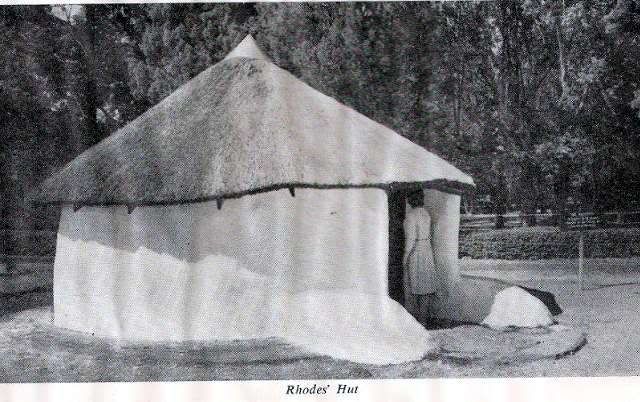
All people seeking permission to hunt or prospect had to camp in this area until granted an interview with Lobengula.
The site is marked with a bronze plaque. The area available stretched down to the small river.
The present O.K. Bazaars building was erected on a stand that contained not only the offices of Goldfields Consolidated Ltd., but also the small wood and iron office of Cecil John Rhodes.
Not far from the outskirts of the City is the farm Umvutcha. This farm is on the site of another of Lobengula's kraals and it was here that the Rudd Concession was signed. On the same farm is the tree named the "Missionary Tree" under which people used to gather to while away the time waiting for an interview with the King.
The Pioneer WellThis is in the gardens surrounding Bulawayo's City Hal] and was used by the people of Bulawayo who laagered there during the Matabele Rebellion.
Bulawayo is a town full of the history of the Matabele people and of the early travellers and hunters.
The early missionaries settled at Old Bulawayo, Hope Fountain, Shilo and Inyati, bringing medicine and learning, as well as spiritual and bodily comfort to many.
The very names of the suburbs, streets and roads recall the early days of settlement here.
Kumalo, the name of the royal family, Famona and Malindela were names of royal wives. Queens Road was the route which led to the kraal of Lobengula's Queens. Lobengula Street, Rhodes Street. Fort Street, (where once stood a rebellion fort), Colenbrander Avenue, Sauerstown and many more too numerous to mention.
Hillside DamsThis beauty spot and bird sanctuary is well worth a visit as it is only a few minutes drive from the centre of the city. On a hot day the sight of cool water and lovely green grass is a relief from the hot tar of the city streets.
Many birds may be seen in the area, but alas, the migrant duck rarely settle on these stretches today.
A collection of aloes has been planted in amongst the kopjes. These make a magnificent splash of colour during the flowering season.
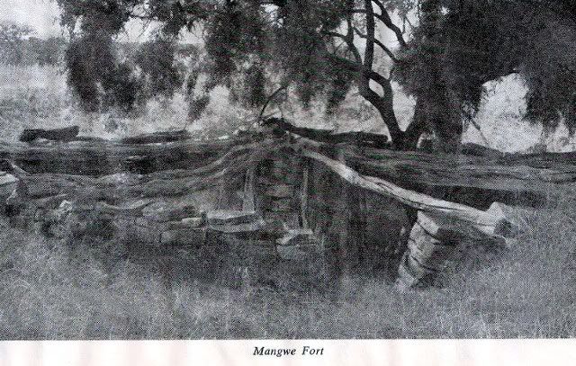 Lee's House and Mangwe Fort
The road to these two historic sites is not very good after the Police Post at Mangwe. There is a sandy river crossing which may stop the driver of a standard vehicle. However, the drive to Mangwe itself is quite pleasant.
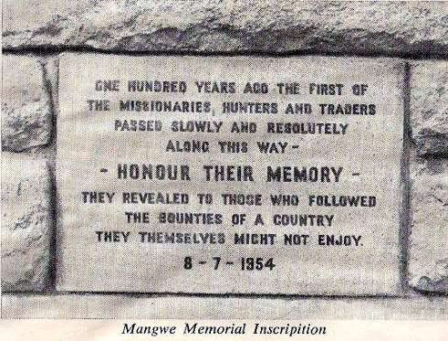
Leave Bulawayo on the Plumtree road and take the left hand road at Marula This turn-off is 39 miles from Bulawayo. Nineteen miles along the Mangwe road the top of the Mangwe Pass will be reached. A memorial erected there records the fact that the first missionaries, hunters and traders passed this spot during 1854. Not only was this route taken by the pre-pioneers but it was the way through which the relief columns came into the country during the Matabeleland rebellion.
It is said that the oracle at Njelele had advised Lobengula not to close the pass because this was the way the white men would run out. Unfortunately for the Matabele the oracle gave them bad advice.
From this point drive as far as the police post at Mangwe. A track leads from there to Fort Mangwe which lies about half a mile from the sandy drift.
The fort consists of a
vallum with trench in front. Some of the original stakes with which the rampart was protected are still in position.
In the centre of the rectangular fort is a circular chamber about 20 feet in diameter; in the centre is a stone built column which supported the timber forming the roof.
This central room was presumably designed as a storeroom and shelter for the women and children while the wagons were laagered within the rectangular area.
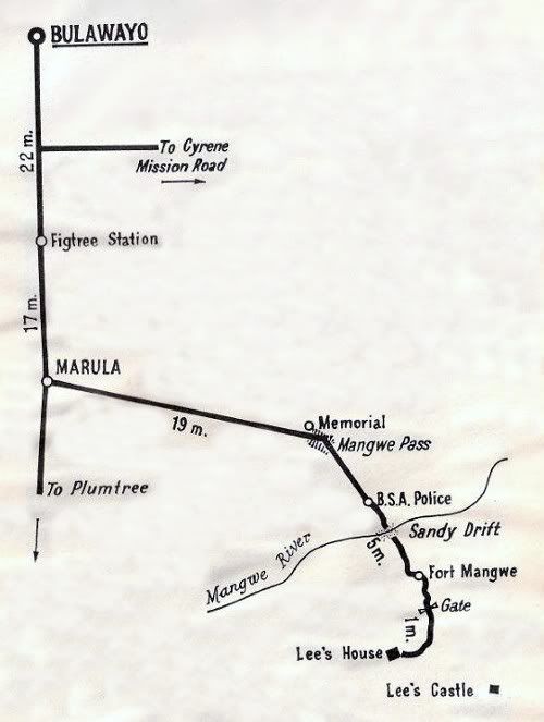
There are people living in the area who sheltered in this fort during the rebellion. No action took place here, but this was one of the forts which guarded the road from Lee's Castle to Bulawayo.
Fort Luck also is not far from Mangwe but there is no road or track to it.
About one mile from the Mangwe Fort are the remains of Lee's house.
John Lee was the first hunter to settle in the district and was its founder. He was a very colourful personality, son of a Royal Navy captain and, through his mother, a relation of President Kruger.
He came to the country when he was aged little more than 30. He gained the confidence of Mziligazi and was appointed his agent. His estate covered, by agreement with Mziligazi, something over 200 square miles.
His stone built house was the centre for travellers during the dry season and the resting place for hunters during the rains. Many well-known personalities stayed at Lee's house including Thomas Baines, the artist.
Lee refused to co-operate against the Matabele and, after the occupation, his lands were confiscated. The incident reflects more honour upon Lee, who was supporting his friends and benefactors, than on the administration.
The very distinctive "castle Kopje" which can be seen for many miles around was a well-known landmark to the early traveller and it became known as Lee's Castle.
 Essexvale Area
Leave Bulawayo on the Johannesburg Road and drive towards Essexvale; 19 miles from the City you will find a turn-off with directions along a good gravel road to Diana's Pool and the Rhodes' Indaba Site. Just over ten miles along this road you will cross the Mzingwane River on a concrete drift. This can be impassable after heavy rain.
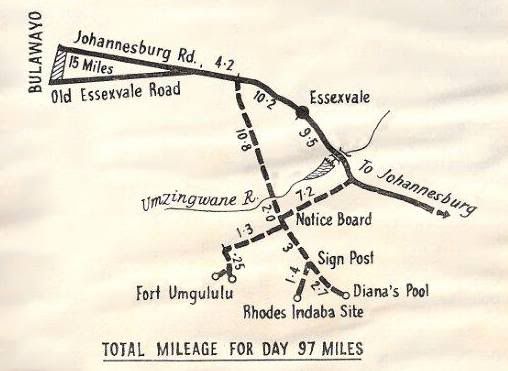
Approximately three miles further on a small notice points to Fort Umlugulu. Turn right at this point through the African village and drive along this road 1.3 miles. Then just across a drift you will see a notice directing you to the fort which is a quarter of a mile from this point.
The road from the village to the drift is part of the Pioneer road that led from Fort Tuli to Bulawayo.
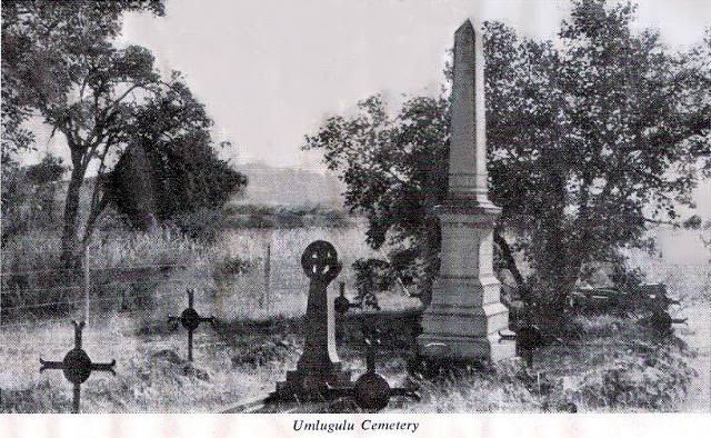
No action was ever fought at this fort but many engagements took place in the nearby hills between the tribesmen and the men who laagered here. A cemetery nearby contains the remains of men who were killed in these engagements.
Baden-Powell was one of the members of the small party that used the fort. It is said that he first thought of the idea of the Boy Scout movement during his scouting expeditions into the hills.
It was from this fort that J. P. Richardson, a Native Commissioner and Zulu linguist, went alone into the hills at very greatpersonal risk to arrange the meeting of the Chiefs which culminated in the first Indaba, at what we now call Rhodes Indaba Site. The Indaba took, place on August 21, 1896. Mr. Rhodes with Dr. Sauer, Mr. Vere Stent and Mr. Colenbrander and a friendly native John Grootboom went into the hills, unarmed to confer with the Matabele chiefs.
As a result of this indaba, Mr. Rhodes convinced the chiefs that if they would give up their arms and return to their kraals there would be no retaliation. The indunas agreed to surrender upon these terms and the unfortunate rebellion was at an end.
To reach the ant heap around which the Indaba was held, return through the African settlement turning to the right at the notice board. Three miles from this point is a notice board giving directions to the site approximately one and a half miles away.
Return on the same road and turn right to Diana's Pool. This is one of the beauty spots in the southern Matopo Hills with perennial running water, lovely shady mountain acacia trees and beautiful views of the surrounding hills.
The flora and fauna are protected under the powers granted to the Rhodesia Forestry Commission.
It is necessary to return towards Bulawayo on the same road as far as the turn-off to Umlugulu. Just beyond this point is a signpost to Balla Bulla: take this road until you meet the main Bulawayo-Johannesburg road 13 miles from Diana's Pool and then turn left.
The bridge across the Mzingwane River at this point is named the Parke Richardson Bridge after the man who so gallantly risked his life to arrange the Indaba.
This road will take you back to Bulawayo from where many trips may be taken into the Matopo Hills where much of the history of the Pioneer Period was enacted.
The painted caves, the historic and prehistoric times of Rhodesia are described in another handbook, published by the Historical Monuments Commission, which may be obtained from the Publicity Association, booksellers, or from the office of the Commission in York House. 8th Avenue, Bulawayo, or P.O. Box 3248.
 The Pioneer Road
If the traveller is returning to the Republic via the direct route from Bulawayo to Beit Bridge 36 miles south of West
Nicholson he will cross the road which the Pioneers used on their trek from Fort Tuli to Fort Victoria and eventually to
Fort Salisbury. This road has been marked with permanent beacons for much of its length. This important task was
carried out by the members of the Matabeleland branch of the Rhodesian Schools Exploration Society. A plaque
indicating the distance to the actual crossing has been erected at the layby containing a large baobab tree just south of
the old crossing.
ACKNOWLEDGMENTSThe Sunday News (Bulawayo) is thanked for permission to use maps and material published under the nom-de-plume
Wanderer. Much use has been made in the handbook of the Guide to Khami Ruins published by the Historical Monuments Commission and written by Mr. K. R. Robinson.. F.R.A.I., one time its Chief Inspector.
GLOSSARYDaga: Mud
Impi: Regiment
Induna: Regimental Commander
Dhlo Dhlo: A Zulu headring
Indaba: A meeting
Mambo: Chief
Kopje: A small hill
Rondavel: A round hut
End of ArticleRecompiled, by Eddy Norris, from a copy of the booklet made available by Diarmid Smith. Thanks Diarmid
Original booklet was printed in 1965
Please note that the copy of the booklet used was damaged by water - but I think the results are good
The recompilation was done for no or intended financial gain but rather to record the memories of Rhodesia.
Thanks to
Paul Norris for the ISP sponsorship.
Paul Mroz for the image hosting sponsorship.
Robb Ellis for his assistance.Should you wish to contact Eddy Norris please mail me on
orafs11@gmail.com 