Around Rhodesia No. 3
Lake Kariba - Sinoia Caves - Salisbury - The Midlands

LAKE KARIBA

Lake Kariba is many things — 5 000 square kilometres of blue, island-studded water, fringed by mountains — a year-round source of water for an abundant animal and bird life — a playground for water-sport enthusiasts — and home of the most challenging fresh-water fishing in Africa.
Yet it was never intended to be any of these things, for the damming of the Zambezi River by the slender 128-metre-high concrete wall, completed in 1961 ( picture A), was undertaken to provide hydro-electric power for the industries of Rhodesia and Zambia.
Humans were not the only ones displaced by the lake as it grew. Animals were marooned on hilltops that overnight became islands, and which often disappeared altogether. To rescue them, Operation Noah was organised, and thousands of animals, from elephants to snakes, were saved in an operation that caught the imagination of the world. At Kariba township which is built on steep hills 370 metres above the lake, less than 20 years ago there was only a construction
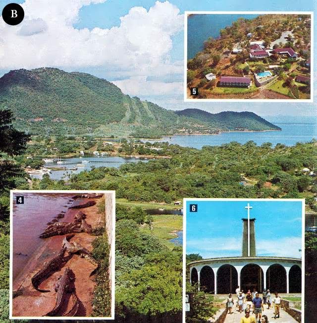
camp for workers on the dam and power station. Since then development has been rapid, particularly along the wooded lake shore (main picture right). Here hotels and harbours have been created, providing sophisticated amenities for the many tourists who drive on modern highways, or fly on Air Rhodesia's daily scheduled service, to this popular holiday area.
There are five modern hotels at Kariba township each with its own individual character (inset B5), and all overlook the lake. There is also a choice of caravan and camping parks, for the warm climate at Kariba encourages the outdoor life.
A day of sightseeing at Kariba township may include a visit to the dam wall, and a tour of the township with its many viewpoints over the lake and its unique church of St Barbara (inset 6) which is built in the shape of a coffer dam and which commemorates the workers who lost their lives in the construction of the dam and power station.
The visitors may also hire sailing dinghies and power boats from a number of operators, learn to water ski, or join regular cruises. Everyone who visits Kariba should embark on the lake, for it is only from this vantage point that the immensity of this inland sea can be appreciated.
Some cruises skirt the shoreline and visitors may see, particularly in the late afternoons, animals coming to drink or wallow in the shallows.
A visit to the Kariba crocodile farm (inset B4) is an opportunity to see at close quarters, and photograph, hundreds of these reptiles, from those a few centimetres long to three-metre giants.
In the evenings hotels often hold dances, film shows are provided, and a visit to the Kariba Casino is an opportunity to play roulette (insert A2), blackjack or chemin de fer.
Beyond the developed area of Kariba township near the dam wall, Lake Kariba extends westwards for 281 kilometres. This is largely untouched wilderness, where small lake-shore resorts and safari companies provide facilities for the visitor who wishes to enjoy the solitude and scenic splendour of these remote areas with their superb game-viewing and fishing.
The largest body of water at Kariba is the vast eastern basin, which extends 32 km south from Kariba township and 65 kilometres from the eastern shore to the resort hotel of Bumi Hills.
Along the southern shore, extending west from the dramatic Sanyati Gorge (the entrance to which can be seen towards the left-hand side of the main picture above), is the 1 370 square-kilometre Matusadona National Park. This is a scenic area rich in wild life, and on islands facing the mountains (main picture above) safari operators have established permanent camps from which unique opportunities for viewing and photographing game are provided (insets D4 & D5).
There is also camp accommodation within the national park itself.
At the western end of Lake Kariba are resorts such as Binga (inset D3) and Mlibizi (inset D6) which may be reached by float plane from Kariba township or from turnoffs from the Bulawayo to Victoria Falls highway. From these resorts, or indeed anywhere on the lake, the visitor may pit his skill against the formidable tiger-fish, one of the world's most fierce fighters. Tiger-fish are not the only quarry for the angler, for bream, chessa, nkupi and vundu also provide good sport.
SINOIA CAVES
The visitor who travels by road south from Kariba, after having climbed from the lower-lying area around the lake to the highveld, passes through an interesting combination of bushveld and highly developed farming country.
On this road is one of Rhodesia's most dramatic minor tourist attractions, the Sinoia Caves.
Here there is a huge natural shaft, 30 metres across and 45 metres deep. At the bottom of this shaft is a pool of crystal-clear water that divers have proved is at least 100 metres deep. The pool may be reached by a long sloping passage through the limestone rock, and due to the lack of surface reflection the impression one gains as one descends is of a vivid blue light.
When the shore of the pool is reached the water is so clear that fish and underwater rock formations may be seen many metres below the surface. Side passages lead the visitor to other viewpoints, both of the pool and the vertical limestone cliffs which rise to a tree-fringed view of the sky.
Archaeologists have found traces of occupation in the caves dating back to the Stone Age, and Selous, the Victorian hunter, naturalist and author, came across these caves in the 1880s on one of his many safaris.
Today the caves are a recreational park, and an hotel and caravan and camping park provide facilities for the visitor. The town of Sinoia, eight kilometres from the caves, is a fast-developing centre of an important farming and mining area, and another hotel and comprehensive shopping facilities may be found here.South of Sinoia, the visitor crosses a range of hills known as the Great Dyke. These hills, which are rich in chrome and other metals, extend like a spine for 550 kilometres from one end of Rhodesia to the other. Beyond the Dyke, the motorist passes through farming country to Rhodesia's capital city, Salisbury.
SALISBURY
Salisbury was born on September 13,1890, when the Pioneer Column raised the flag after their long and hazardous journey from what was then Bechuanaland.
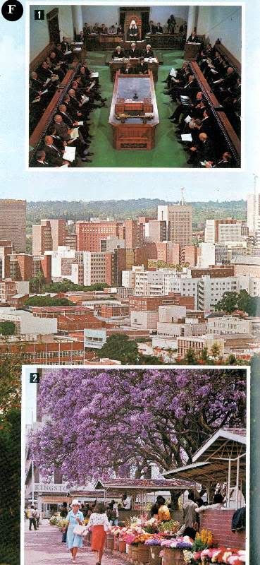
The spacious, modern city (the commercial centre of which may be seen in the main picture right) that has risen from such recent and humble origins is the capital of Rhodesia, has a population of half a million (all races) and extends over 536 square kilometres. Here the visitor may enjoy all the comforts and amenities expected of a modern city.
There is accommodation to suit every taste and pocket, from four-star hotels to modest guest-houses. Tour operators provide a full range of daily tours of the city and surrounding areas, there is a choice of car-rental agencies, and a comprehensive taxi service.
As the capital, Salisbury is the administrative, judicial and communications centre of the country. In the Rhodesian Parliament, the visitor may watch the legislators at work (inset F1) and, when the House of Assembly or Senate are not sitting, conducted tours of the building with its historic possessions are permitted.
The visitor may also find the National Archives galleries with their displays of Thomas Baines' paintings and other historical treasures, of interest. Certainly the Queen Victoria Museum with its lifelike displays depicting the history of man and animals in Mashonaland should not be missed.
One of the glories of Salisbury, softening the hard lines of high-rise modern buildings, is the display of colour afforded by the flowering trees which line the streets (inset F2). In September and October the purple jacarandas give their name to the city's annual festival held in early October, when cultural and sporting events provide a concentrated programme of entertainment.
The jacarandas are followed by the brilliant flamboyants, the spathodias, bauhinias and many others. More natural colour may be seen in the Cecil Square flower market (inset F2), where vivid local and exotic blooms provide an extensive, ever-changing display.
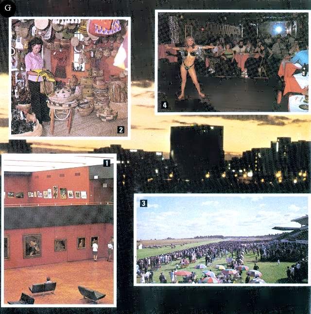
Displays of African sculpture and art may also be seen at the National Gallery (inset G1) where collections representing the principal European schools are also on display. Specialised exhibitions are also held throughout the year.
Entertainment at night is provided by theatres, cinemas and night clubs (inset G4). The city also has a very wide range of restaurants, offering menus from all corners of the world. The visitor should also ensure he samples Rhodesia's national dish — a man-size steak.
Sport plays an important part in the Rhodesian weekend, and the visitor may visit the beautiful Borrowdale racecourse on the outskirts of the city (inset G3) where meetings are held throughout the year. Regular trotting races are also held at another track. In their season, rugby, football, cricket, tennis, polo, and many other sports may be watched.
With its abundance of open spaces Salisbury offers a choice of over a dozen golf courses, some within sight of the city centre's high-rise buildings. Visitors will find the green fees to be most reasonable. There are also many bowls clubs where the visitor will find a warm welcome.
Salisbury also has an international standard motor-racing circuit at Donnybrook on the outskirts of the city. Here racing, from Formula I to motor-cycles, takes place regularly during the year. The exciting sport of motor-cycle scrambling also takes place here during most weekends.
There are places of interest beyond the immediate city area. Ewanrigg Botanical Garden (inset H8) 35 kilometres from Salisbury is a world-famous display of colourful aloes and ancient palm-like cycads. These are seen at their best during the peak flowering periods of July and August, but are an impressive sight at any time of the year. The 24 hectares of landscaped gardens are set within 283 hectares of natural woodland.
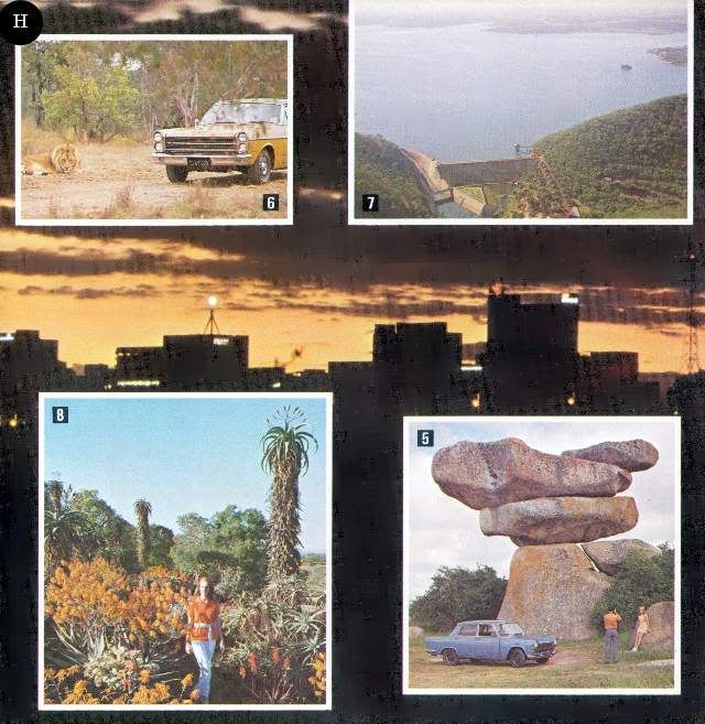
12 kilometres south of Salisbury is an area of massive granite rocks which vividly display one of the memorable features of the Rhodesian landscape, its granite rock formations. Sculptured by rain and wind, many formations have acquired fantastic balancing shapes (inset H5). On the sheltered faces of some of these features are ancient rock paintings.
35 kilometres west of the city is Lake Mcllwaine, the country's third-largest lake and, like all the others, man-made (inset H7). This 57-square-kilometre stretch of water and its shoreline form the Robert Mcllwaine Recreational Park.
The north bank of the lake has been developed to provide recreational facilities, including an hotel, restaurants, and caravan and camping sites.
On the southern shore the natural surroundings have been protected and an extensive game park established. The combination of woodland and lake-side environments has also encouraged an unusually wide variety of bird life and some ornithologists have made counts of over 200 species in a single day.
On the road from the city to Lake Mcllwaine is a private lion and cheetah park where the photographer will find opportunities of making a close study of lion (inset H6), cheetah and many other species kept here.
THE MIDLANDS
The Midlands of Rhodesia may be said to extend from Gatooma in the north to Selukwe in the south.
Although the province does not possess any of the internationally famous tourist attractions which draw the visitor to Rhodesia, there are many areas in and around the principal population centres which are of more than passing interest Each urban centre offers a choice of hotel accommodation, and there are numerous caravan and camping parks. Golf clubs and sporting clubs welcome visitors.
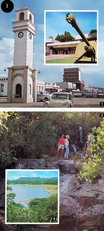
Gwelo (picture I1) is the largest centre in the Midlands and is the provincial capital. In addition to being an important communications and administration centre, it is a major industrial complex and a focus for the flourishing cattle ranches which surround it.
Established in 1894, the city now has a population of 68 000 (all races). Its shopping facilities are varied and sophisticated, and accommodation for visitors is provided in a choice of hotels and a centrally situated caravan park.
Near the municipal offices, which are designed in a distinctive Rhodesian-colonial style of architecture, is a large and attractive public park, and there is also a public swimming pool. Adjacent to the park is the Midlands Museum (inset 2), which specialises in military history, and a modern theatre. For the sportsmen, there is a championship-rated 18-hole golf course and four thriving sports clubs, which welcome visitors.
Gwelo also has its own light railway, which operates on Sunday afternoon and most public holidays on a track adjacent to the main railway station.
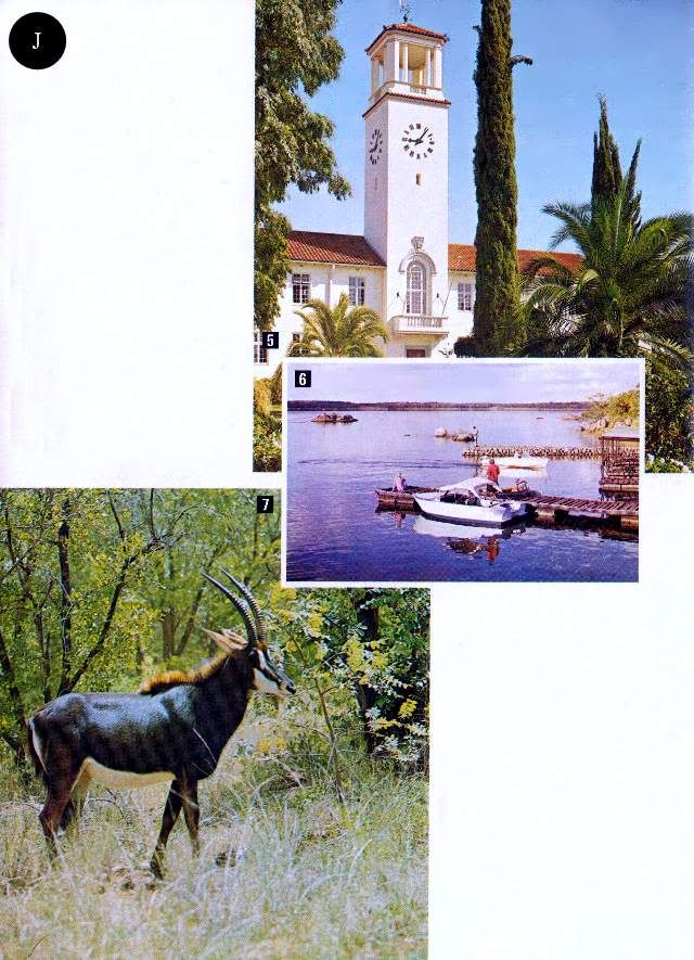
Boating, fishing and other recreational facilities are provided at Whitewaters and Gwenoro Dam, near the city.
South of Gwelo is the scenic area of Selukwe, which is situated on the edge of the central highveld. From drives which wind up into the steep hills surrounding this small town, some of the finest scenic views in Rhodesia may be obtained. Streams descending from the peaks form many picturesque waterfalls such as the Dunraven and Camperdown falls (picture I3).
Within the Midlands area are the Sebakwe Recreational Park (inset J4) and the Ngezi Recreational Park (inset J6). Both have been created around small lakes and offer a quiet retreat for the visitor in pleasant scenic surroundings. There are also opportunities for game-viewing and fishing. Fully furnished National Parks accommodation and caravan and camping sites are available at both parks.
Que Que, halfway between Bulawayo and Salisbury, was established when the Globe & Phoenix Mine was pegged on the site of ancient gold workings in 1894. The headworks of the mine still dominate the town, but although it once produced the world's richest gold ore, its palmy days are over.
A few kilometres north of the town is the Dutchman's Pool Dam, a recreational complex that offers boating, fishing, caravan and camping facilities and a game park, Sable Park, where a small population of this majestic antelope (picture J7) may be seen. South of the town is Redcliff, where Rhodesia's massive iron and steel producing complex is situated.
Yet it was never intended to be any of these things, for the damming of the Zambezi River by the slender 128-metre-high concrete wall, completed in 1961 ( picture A), was undertaken to provide hydro-electric power for the industries of Rhodesia and Zambia.
Twenty years ago the remote Zambezi Valley, now inundated for ever, was the home of the Batonka people, whose quaint homes, built on stilts, may be seen today at Kariba's Craft Village (inset A3). The Batonkas held that the river spirit, Nyaminyami (inset A1) would never allow the completion of the dam, and often refused to leave their villages until they were forced to by the rising waters. They still believe he waits, in the depths of the lake, to free the river from its bondage. When the great gates in the dam wall are opened, each discharging 1,5 million litres of water a second, it is easy to imagine a primitive and hostile force at work.
Humans were not the only ones displaced by the lake as it grew. Animals were marooned on hilltops that overnight became islands, and which often disappeared altogether. To rescue them, Operation Noah was organised, and thousands of animals, from elephants to snakes, were saved in an operation that caught the imagination of the world. At Kariba township which is built on steep hills 370 metres above the lake, less than 20 years ago there was only a construction

camp for workers on the dam and power station. Since then development has been rapid, particularly along the wooded lake shore (main picture right). Here hotels and harbours have been created, providing sophisticated amenities for the many tourists who drive on modern highways, or fly on Air Rhodesia's daily scheduled service, to this popular holiday area.
There are five modern hotels at Kariba township each with its own individual character (inset B5), and all overlook the lake. There is also a choice of caravan and camping parks, for the warm climate at Kariba encourages the outdoor life.
A day of sightseeing at Kariba township may include a visit to the dam wall, and a tour of the township with its many viewpoints over the lake and its unique church of St Barbara (inset 6) which is built in the shape of a coffer dam and which commemorates the workers who lost their lives in the construction of the dam and power station.
The visitors may also hire sailing dinghies and power boats from a number of operators, learn to water ski, or join regular cruises. Everyone who visits Kariba should embark on the lake, for it is only from this vantage point that the immensity of this inland sea can be appreciated.
Some cruises skirt the shoreline and visitors may see, particularly in the late afternoons, animals coming to drink or wallow in the shallows.
A visit to the Kariba crocodile farm (inset B4) is an opportunity to see at close quarters, and photograph, hundreds of these reptiles, from those a few centimetres long to three-metre giants.
In the evenings hotels often hold dances, film shows are provided, and a visit to the Kariba Casino is an opportunity to play roulette (insert A2), blackjack or chemin de fer.

Beyond the developed area of Kariba township near the dam wall, Lake Kariba extends westwards for 281 kilometres. This is largely untouched wilderness, where small lake-shore resorts and safari companies provide facilities for the visitor who wishes to enjoy the solitude and scenic splendour of these remote areas with their superb game-viewing and fishing.
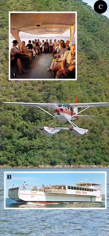
Communications between Kariba township and other areas of the lake are comprehensive. For those short of time a convenient and speedy float-plane charter service ( picture C left) may be utilised. This company also offers game-viewing and scenic flights. A large ferry vessel (inset C2) provides both short cruises and extended game-viewing and fishing safaris, with passengers sleeping on board at a sheltered anchorage each night Boat operators also hire a range of craft,from fishing boats to fast cruise boats (inset C1), all under the care of licensed coxswains.

The largest body of water at Kariba is the vast eastern basin, which extends 32 km south from Kariba township and 65 kilometres from the eastern shore to the resort hotel of Bumi Hills.
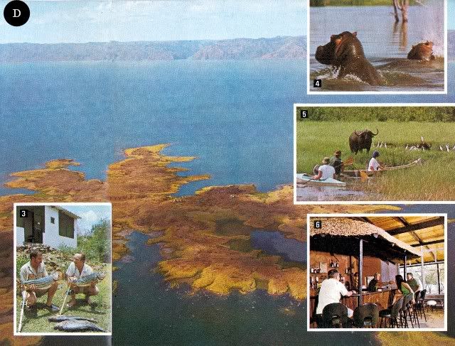
Along the southern shore, extending west from the dramatic Sanyati Gorge (the entrance to which can be seen towards the left-hand side of the main picture above), is the 1 370 square-kilometre Matusadona National Park. This is a scenic area rich in wild life, and on islands facing the mountains (main picture above) safari operators have established permanent camps from which unique opportunities for viewing and photographing game are provided (insets D4 & D5).
There is also camp accommodation within the national park itself.
At the western end of Lake Kariba are resorts such as Binga (inset D3) and Mlibizi (inset D6) which may be reached by float plane from Kariba township or from turnoffs from the Bulawayo to Victoria Falls highway. From these resorts, or indeed anywhere on the lake, the visitor may pit his skill against the formidable tiger-fish, one of the world's most fierce fighters. Tiger-fish are not the only quarry for the angler, for bream, chessa, nkupi and vundu also provide good sport.
SINOIA CAVES

The visitor who travels by road south from Kariba, after having climbed from the lower-lying area around the lake to the highveld, passes through an interesting combination of bushveld and highly developed farming country.
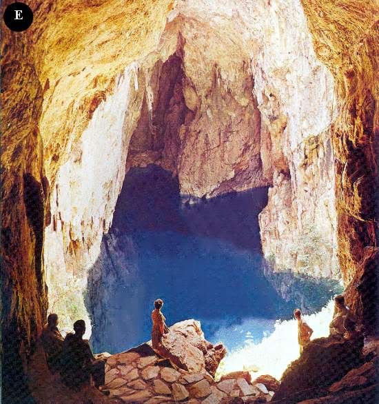
On this road is one of Rhodesia's most dramatic minor tourist attractions, the Sinoia Caves.
Here there is a huge natural shaft, 30 metres across and 45 metres deep. At the bottom of this shaft is a pool of crystal-clear water that divers have proved is at least 100 metres deep. The pool may be reached by a long sloping passage through the limestone rock, and due to the lack of surface reflection the impression one gains as one descends is of a vivid blue light.
When the shore of the pool is reached the water is so clear that fish and underwater rock formations may be seen many metres below the surface. Side passages lead the visitor to other viewpoints, both of the pool and the vertical limestone cliffs which rise to a tree-fringed view of the sky.
Archaeologists have found traces of occupation in the caves dating back to the Stone Age, and Selous, the Victorian hunter, naturalist and author, came across these caves in the 1880s on one of his many safaris.
Today the caves are a recreational park, and an hotel and caravan and camping park provide facilities for the visitor. The town of Sinoia, eight kilometres from the caves, is a fast-developing centre of an important farming and mining area, and another hotel and comprehensive shopping facilities may be found here.South of Sinoia, the visitor crosses a range of hills known as the Great Dyke. These hills, which are rich in chrome and other metals, extend like a spine for 550 kilometres from one end of Rhodesia to the other. Beyond the Dyke, the motorist passes through farming country to Rhodesia's capital city, Salisbury.
SALISBURY

Salisbury was born on September 13,1890, when the Pioneer Column raised the flag after their long and hazardous journey from what was then Bechuanaland.
The spacious, modern city (the commercial centre of which may be seen in the main picture right) that has risen from such recent and humble origins is the capital of Rhodesia, has a population of half a million (all races) and extends over 536 square kilometres. Here the visitor may enjoy all the comforts and amenities expected of a modern city.
There is accommodation to suit every taste and pocket, from four-star hotels to modest guest-houses. Tour operators provide a full range of daily tours of the city and surrounding areas, there is a choice of car-rental agencies, and a comprehensive taxi service.
As the capital, Salisbury is the administrative, judicial and communications centre of the country. In the Rhodesian Parliament, the visitor may watch the legislators at work (inset F1) and, when the House of Assembly or Senate are not sitting, conducted tours of the building with its historic possessions are permitted.
The visitor may also find the National Archives galleries with their displays of Thomas Baines' paintings and other historical treasures, of interest. Certainly the Queen Victoria Museum with its lifelike displays depicting the history of man and animals in Mashonaland should not be missed.
One of the glories of Salisbury, softening the hard lines of high-rise modern buildings, is the display of colour afforded by the flowering trees which line the streets (inset F2). In September and October the purple jacarandas give their name to the city's annual festival held in early October, when cultural and sporting events provide a concentrated programme of entertainment.
The jacarandas are followed by the brilliant flamboyants, the spathodias, bauhinias and many others. More natural colour may be seen in the Cecil Square flower market (inset F2), where vivid local and exotic blooms provide an extensive, ever-changing display.

The visitor's shopping interest will naturally focus on the many curio shops in the city. Goods in glowing Rhodesian copper and animal skins are available, and some shops specialise in authentic products made by African villagers in local natural materials (inset G2). Sculptures in wood and soapstone are of a very high quality and are frequently available at bargain prices.
Displays of African sculpture and art may also be seen at the National Gallery (inset G1) where collections representing the principal European schools are also on display. Specialised exhibitions are also held throughout the year.
Entertainment at night is provided by theatres, cinemas and night clubs (inset G4). The city also has a very wide range of restaurants, offering menus from all corners of the world. The visitor should also ensure he samples Rhodesia's national dish — a man-size steak.
Sport plays an important part in the Rhodesian weekend, and the visitor may visit the beautiful Borrowdale racecourse on the outskirts of the city (inset G3) where meetings are held throughout the year. Regular trotting races are also held at another track. In their season, rugby, football, cricket, tennis, polo, and many other sports may be watched.
With its abundance of open spaces Salisbury offers a choice of over a dozen golf courses, some within sight of the city centre's high-rise buildings. Visitors will find the green fees to be most reasonable. There are also many bowls clubs where the visitor will find a warm welcome.
Salisbury also has an international standard motor-racing circuit at Donnybrook on the outskirts of the city. Here racing, from Formula I to motor-cycles, takes place regularly during the year. The exciting sport of motor-cycle scrambling also takes place here during most weekends.
There are places of interest beyond the immediate city area. Ewanrigg Botanical Garden (inset H8) 35 kilometres from Salisbury is a world-famous display of colourful aloes and ancient palm-like cycads. These are seen at their best during the peak flowering periods of July and August, but are an impressive sight at any time of the year. The 24 hectares of landscaped gardens are set within 283 hectares of natural woodland.

12 kilometres south of Salisbury is an area of massive granite rocks which vividly display one of the memorable features of the Rhodesian landscape, its granite rock formations. Sculptured by rain and wind, many formations have acquired fantastic balancing shapes (inset H5). On the sheltered faces of some of these features are ancient rock paintings.
35 kilometres west of the city is Lake Mcllwaine, the country's third-largest lake and, like all the others, man-made (inset H7). This 57-square-kilometre stretch of water and its shoreline form the Robert Mcllwaine Recreational Park.
The north bank of the lake has been developed to provide recreational facilities, including an hotel, restaurants, and caravan and camping sites.
On the southern shore the natural surroundings have been protected and an extensive game park established. The combination of woodland and lake-side environments has also encouraged an unusually wide variety of bird life and some ornithologists have made counts of over 200 species in a single day.
On the road from the city to Lake Mcllwaine is a private lion and cheetah park where the photographer will find opportunities of making a close study of lion (inset H6), cheetah and many other species kept here.
THE MIDLANDS

The Midlands of Rhodesia may be said to extend from Gatooma in the north to Selukwe in the south.
Although the province does not possess any of the internationally famous tourist attractions which draw the visitor to Rhodesia, there are many areas in and around the principal population centres which are of more than passing interest Each urban centre offers a choice of hotel accommodation, and there are numerous caravan and camping parks. Golf clubs and sporting clubs welcome visitors.
Gwelo (picture I1) is the largest centre in the Midlands and is the provincial capital. In addition to being an important communications and administration centre, it is a major industrial complex and a focus for the flourishing cattle ranches which surround it.
Established in 1894, the city now has a population of 68 000 (all races). Its shopping facilities are varied and sophisticated, and accommodation for visitors is provided in a choice of hotels and a centrally situated caravan park.
Near the municipal offices, which are designed in a distinctive Rhodesian-colonial style of architecture, is a large and attractive public park, and there is also a public swimming pool. Adjacent to the park is the Midlands Museum (inset 2), which specialises in military history, and a modern theatre. For the sportsmen, there is a championship-rated 18-hole golf course and four thriving sports clubs, which welcome visitors.
Gwelo also has its own light railway, which operates on Sunday afternoon and most public holidays on a track adjacent to the main railway station.
Boating, fishing and other recreational facilities are provided at Whitewaters and Gwenoro Dam, near the city.
South of Gwelo is the scenic area of Selukwe, which is situated on the edge of the central highveld. From drives which wind up into the steep hills surrounding this small town, some of the finest scenic views in Rhodesia may be obtained. Streams descending from the peaks form many picturesque waterfalls such as the Dunraven and Camperdown falls (picture I3).

Within the Midlands area are the Sebakwe Recreational Park (inset J4) and the Ngezi Recreational Park (inset J6). Both have been created around small lakes and offer a quiet retreat for the visitor in pleasant scenic surroundings. There are also opportunities for game-viewing and fishing. Fully furnished National Parks accommodation and caravan and camping sites are available at both parks.
Que Que, halfway between Bulawayo and Salisbury, was established when the Globe & Phoenix Mine was pegged on the site of ancient gold workings in 1894. The headworks of the mine still dominate the town, but although it once produced the world's richest gold ore, its palmy days are over.
A few kilometres north of the town is the Dutchman's Pool Dam, a recreational complex that offers boating, fishing, caravan and camping facilities and a game park, Sable Park, where a small population of this majestic antelope (picture J7) may be seen. South of the town is Redcliff, where Rhodesia's massive iron and steel producing complex is situated.
Gatooma, the northernmost principal centre of the Midlands, is a typical Rhodesian small town, dominated by its attractive, colonial-style Magistrate's Court building (picture J5). In recent years the establishment of a cotton ginnery and weaving mills has established the town as the country's spinning and cotton centre. The most modern abattoir in Africa, capable of handling 500 carcasses per eight hour shift, is also sited here, as ranching is a major agricultural activity in the surrounding area.
FOR FURTHER READING
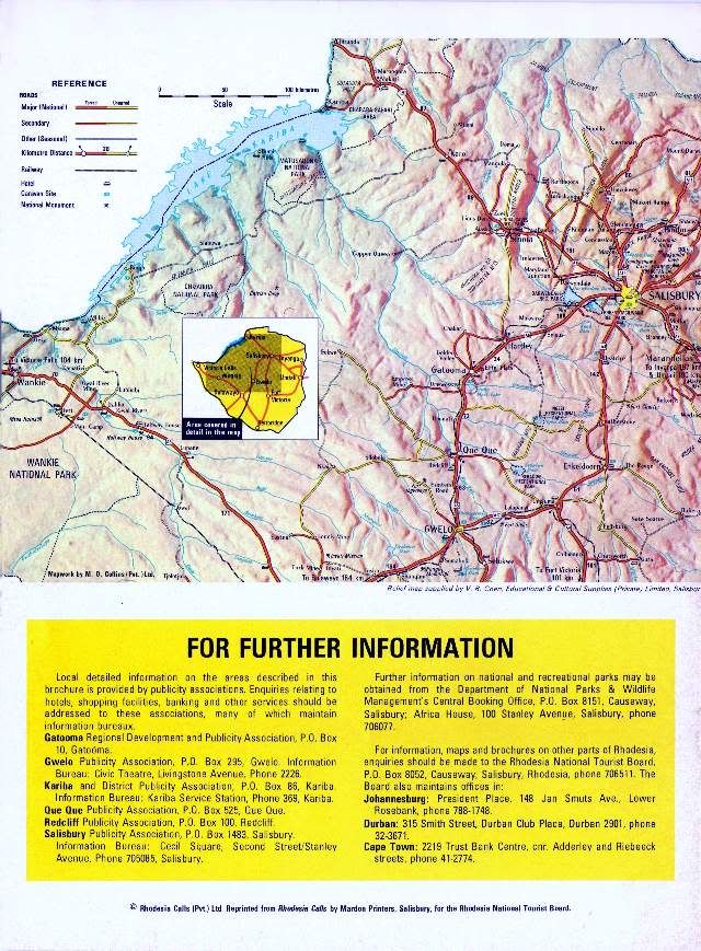
Local detailed information on the areas described in this brochure is provided by publicity associations. Enquiries relating to hotels, shopping facilities, banking and other services should be addressed to these associations, many of which maintain information bureaux.
Gatooma Regional Development and Publicity Association, P.O. Box 10, Gatooma.
Gwelo Publicity Association, P.O. Box 295, Gwelo. Information Bureau: Civic Theatre, Livingstone Avenue, Phone 2226.
Kariba and District Publicity Association, P.O. Box 86, Kariba. Information Bureau: Kariba Service Station, Phone 369, Kariba.
Que Que Publicity Association, P.O. Box 525, Que Que.
Redcliff Publicity Association, P.O. Box 100, Redcliff.
Salisbury Publicity Association, P.O. Box 1483, Salisbury. Information Bureau: Cecil Square, Second Street/Stanley Avenue, Phone 705085, Salisbury.
Further information on national and recreational parks may be obtained from the Department of National Parks & Wildlife Management's Central Booking Office, P.O. Box 8151, Causeway, Salisbury; Africa House, 100 Stanley Avenue, Salisbury, phone 706077.
For information, maps and brochures on other parts of Rhodesia, enquiries should be made to the Rhodesia National Tourist Board, P.O. Box 8052, Causeway, Salisbury, Rhodesia, phone 706511. The Board also maintains offices in:
Johannesburg: President Place, 148 Jan Smuts Ave., Lower Rosebank, phone 788-1748.
Durban: 315 Smith Street, Durban Club Place, Durban 2901, phone 32-3671.
Cape Town: 2219 Trust Bank Centre, cnr. Adderley and Riebeeck streets, phone 41-2774.
© Rhodesia Calls (Pvt.) Ltd. Reprinted from Rhodesia Calls by Mardon Printers, Salisbury, for the Rhodesia National Tourist Board.
End of Article
Recompiled, by Eddy Norris, from a copy of the booklet made available by Diarmid Smith. Thanks Diarmid
The recompilation was done for no or intended financial gain but rather to record the memories of Rhodesia.
Thanks to
Paul Norris for the ISP sponsorship.
Paul Mroz for the image hosting sponsorship.
Robb Ellis for his assistance.
Should you wish to contact Eddy Norris please mail me on orafs11@gmail.com

FOR FURTHER READING
Local detailed information on the areas described in this brochure is provided by publicity associations. Enquiries relating to hotels, shopping facilities, banking and other services should be addressed to these associations, many of which maintain information bureaux.
Gatooma Regional Development and Publicity Association, P.O. Box 10, Gatooma.
Gwelo Publicity Association, P.O. Box 295, Gwelo. Information Bureau: Civic Theatre, Livingstone Avenue, Phone 2226.
Kariba and District Publicity Association, P.O. Box 86, Kariba. Information Bureau: Kariba Service Station, Phone 369, Kariba.
Que Que Publicity Association, P.O. Box 525, Que Que.
Redcliff Publicity Association, P.O. Box 100, Redcliff.
Salisbury Publicity Association, P.O. Box 1483, Salisbury. Information Bureau: Cecil Square, Second Street/Stanley Avenue, Phone 705085, Salisbury.
Further information on national and recreational parks may be obtained from the Department of National Parks & Wildlife Management's Central Booking Office, P.O. Box 8151, Causeway, Salisbury; Africa House, 100 Stanley Avenue, Salisbury, phone 706077.
For information, maps and brochures on other parts of Rhodesia, enquiries should be made to the Rhodesia National Tourist Board, P.O. Box 8052, Causeway, Salisbury, Rhodesia, phone 706511. The Board also maintains offices in:
Johannesburg: President Place, 148 Jan Smuts Ave., Lower Rosebank, phone 788-1748.
Durban: 315 Smith Street, Durban Club Place, Durban 2901, phone 32-3671.
Cape Town: 2219 Trust Bank Centre, cnr. Adderley and Riebeeck streets, phone 41-2774.
© Rhodesia Calls (Pvt.) Ltd. Reprinted from Rhodesia Calls by Mardon Printers, Salisbury, for the Rhodesia National Tourist Board.
End of Article
Recompiled, by Eddy Norris, from a copy of the booklet made available by Diarmid Smith. Thanks Diarmid
The recompilation was done for no or intended financial gain but rather to record the memories of Rhodesia.
Thanks to
Paul Norris for the ISP sponsorship.
Paul Mroz for the image hosting sponsorship.
Robb Ellis for his assistance.
Should you wish to contact Eddy Norris please mail me on orafs11@gmail.com
posted by Rhodesia Remembered @ 14:56
1 Comments
![]()
![]()


