In Search Of A Lost Grave
(The Salisbury North Exploration Young Farmers' Club conducts an expedition to find the grave of Henry Hartley's teenage son.)
Long before the Pioneer Column opened up Mashonaland to European influences the interior of Southern Africa had acted as a magnet to hunters, traders and prospectors alike. Many Europeans must have died in those years prior to 1890, but no marked graves are known.
From various papers and diaries of the time, it is known that in 1870 about 19 Europeans entered Mashonaland to hunt ivory, and that no less than seven died from either malaria or dysentery. One of those deaths has left an intriguing mystery which, until the present day, has not really been solved.
William Hartley was the son of the famous hunter, Henry Hartley, and during the early part of 1870, was travelling to the rich ivory hunting grounds of Mashonaland. The year was a disastrous one for the seasonal hunters as wet weather persisted until May, and malaria was virulent between Tati and the hunting grounds.
At the beginning of May, William Hartley and his companion, James O'Donnell, came down from Thaba Insimpi and met up with Thomas Leask, who was camped on the Chirundazi. After spending a few days at the camp. Hartley, in company with O'Donnell and two other hunters, set off to cross the Umfuli, towards the Hunyani. Fourteen days later, Leask, who had trekked south-east to higher ground, received a message that Hartley's group was stricken with fever and needed help.
In spite of Leask's ministrations, William Hartley died at midday on Sunday, May 29, aged 17 years. Later that evening, James O'Donnell also died.
Leask, in his diary of that time, makes no mention of Hartley's grave or burial; but in August that year, he visited the site again to show the place to the boy's father, who had arrived at the beginning of August. Thomas Baines and Robert Jewell, a photographer, were with them.
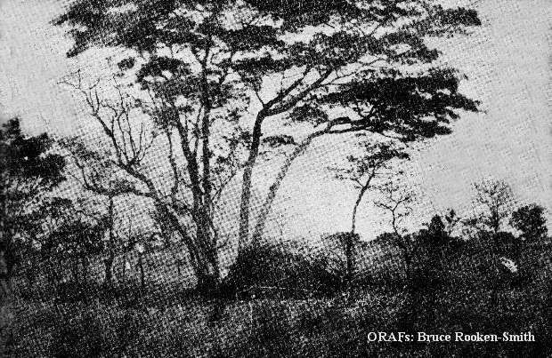
The actual grave site has been, owing to the passing years, shrouded in mystery. It is known that Leask carved William Hartley's name and the date of his death on a tree which stood at the head of the grave, and Baines's "Gold Region of South Eastern Africa" gives a longitude and latitude position. But time, nature, and the human element have combined forces in such a way as to create a continual mystery regarding William Hartley's true resting place.
It was this sense of mystery and challenge that led the Salisbury North Exploration Young Farmers' Club to set about finding Hartley's grave. Attempts by various people had been made in the past, but without success
The Club leader, the late Mr Robert (Bicky) Bicknell, encouraged members to go over diaries, papers and published works for any information, hints or clues to the grave site. On a previous expedition, the Club had established the fact that the present Hartley Hills was in fact Fort Hill; therefore, using this infomation, it would seem that previous attempts had been five miles to the west of the actual area, and that the true site was not far from the banks of the Chirundazi.
Comparing Baines's co-ordinates with a modern map, it was found that the longitude was too far to the west. His latitude, however, was very close tr the correct position. It appeared Baines relied heavily on dead reckoning, which at the best of times was a "hit or miss" affair. In his book he gave the longitude of the grave as 30°59'; the club members found that by apply a correction of 25' 30", it brought the longitude of the grave to 30° 27' 29" east.
From other information obtained by the Club, it was apparent that the site would have to fulfil three important requirements: it had to be near sufficient water to cater for 120 oxen and horses, and yet not pollute it for human consumption; it had to coincide with Baines' map showing the routes he took on his journeys; and it also had to be between the Umfuli and Chirundazi Rivers.
The Club decided to organise a full expedition to the Hartley Hills area and to divide it into "search" squares. Their first requirement was to check out information contained in a fairly recent published paper, which put the site of Hartley's grave on the edge of a vlei leading into the Tumbwi stream from the north-west, about one mile from Mashayamombe School. But after checking and re-checking co-ordinates and information at hand, it was proved that the site could not possibly be Hartley's grave.
The next step was to find the Hunter's Road Drift over the Umfuli and try to re-trace the route as given in Baines's diary.
The Club trekked from the southern bank of the river, through a veritable jungle of "wait-a-bit" thorn bushes before they reached the top of a bank near the weir. Beyond this was another steep bank, covered with boulders, sharp-leafed reeds, and dense undergrowth. Less than a kilometre below the weir, they found they were opposite the road on the north bank.
At first it was impossible to see any signs of a road, but, after two hours of exploration, the road was seen ascending through a cutting with steep banks rising on each side. At the top, members found what they first took to be a gully, with water standing at the bottom; but, upon investigation, it was realised this was Sir John Swinbourne's gold diggings, which he had worked in 1869. This was the final proof that this was Hunter's Road Drift.
The expedition was now in a spot of correction in a square of approximately 50 metres, on the east bank of the Chirundazi. Information obtained from local Africans indicated there was a grave nearby; in actual fact, the grave was discovered approximately 300 metres from their calculated position with the corrected co-ordinates.
The site corresponded exactly with the expedition's interpretation of Jewell's picture taken in 1870 — a vlei, with rocky outcrops in the background. The outcrops, it was felt, would account for the fact that Hartley's grave was only covered with brushwood at the time of his burial, but that his father would have travelled the necessary distance and bought back stone in order to give his son some final recognition. Of the tree there was, of course, no sign, but a msasa tree alive in 1870 would be unlikely to have survived for more than 100 years.
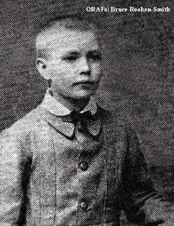
Above: Willie Hartley, aged 13
Below: This photograph of Willie s grave was taken in August 1870, by Robert Jewell, who accompanied Henry Hartley and Thomas Baines to the site
As the soil in that area has a high alkaline content, it was unlikely that any bone remains would survive so long, but the expedition knows from an entry in Henry Hartley's diary that William was buried wearing the family signet ring, which was made from pure gold and contained a large ruby.
To back up the expedition's theory that this was, indeed. Hartley's grave, it was necessary to find the site where O'Donnell was buried as, according to Baines, it was no more than four miles from Hartley's grave. Using a map of the area, the Club established a rocky outcrop some three miles away in a north north-east direction.
Operating in pairs, the Club swept an area of 300 metres square, and eventually came across a site which, although densely overgrown, was unmistakably a grave. All information and co-ordinates checked out that this was definitely the last resting place of James O'Donnell.
At the head of the grave stood a tree on which a small black area of the bark had been, at some time, blazed, leaving a mark about eight centimetres wide. The bark around the area was carefully removed; but the Club could not find any indication of an inscription, and decided to leave further investigation until expert help could be obtained.
Has the Salisbury North Exploration YFC solved the mystery of the final resting place of William Hartley ... can they establish conclusive evidence ... or will William Hartley's grave be lost forever?
That's what the next expedition is all about!
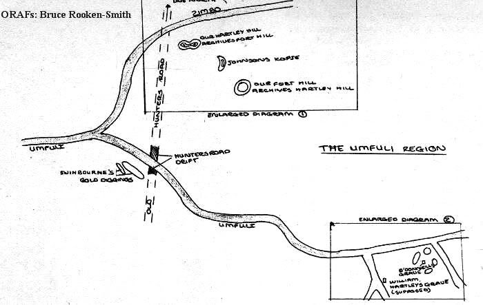
Above: Diagram of the Umfuli Region.
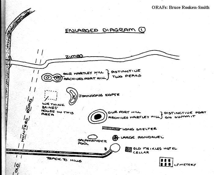
Above: Enlarged diagram of the area of exploration.
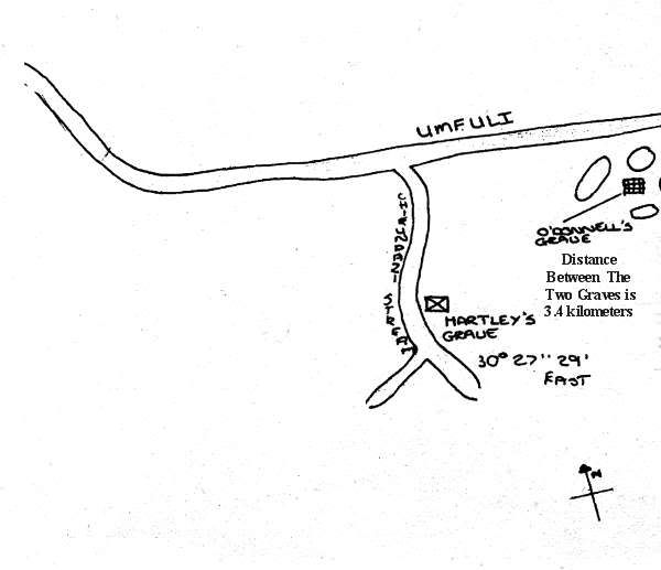
Above: Salisbury North Exploration YFC's site at Willie's grave, together with co-ordinates.
The End.
Extracted and recompiled by Eddy Norris from the magazine Rhodesian Knowledge Number 1, which was made available to ORAFs by Bruce Rooken-Smith. Thank you Bruce.
Please note that this publication was directed to the youth of Rhodesia.
Comments are always welcome, please send them to Eddy Norris at orafs11@gMail.com
Thanks to:-
Paul Norris for the ISP sponsorship.
Paul Mroz for the image hosting sponsorship.
Robb Ellis for his assistance.


1 Comments:
It is a great chance I had to read your amazing article for sure I have cached for future reading.
Story Cutter for Instagram For PC
Post a Comment
Subscribe to Post Comments [Atom]
<< Home