Your Weather Forecasting Service in Rhodesia
NOTES ON BASIC ATMOSPHERIC PROCESSES AND RELATIONSHIPS
PRESSURE AND WIND
When pressure readings from a network of barometric stations are reduced to sea level (or to some other common level), they reveal distinct areas of high and low pressure. The high-pressure systems are known as anticyclones or simply highs', an elongated high may also be called a ridge. Low-pressure systems include tropical cyclones and lows or depressions', and an elongated area of low pressure is. described as a trough. These systems can all be delineated on weather maps by means of isobars, i.e. lines of equal atmospheric pressure.
Because of the deflecting force produced by the spin of the earth, air does not flow direct from high pressure to low. Instead, it blows virtually along the isobars; and the closer together the isobars (ie. the steeper the pressure gradient), the faster the air flows around the various pressure systems. In the southern hemisphere the direction is clockwise around lows and anticlockwise around highs.
The wind patterns themselves may be depicted by means of streamlines', these usually run more or less parallel to each other but they often diverge or converge instead.
TEMPERATURE AND HUMIDITY
Temperatures ordinarily decrease with height, mainly because the sun heats the earth which, in turn, heats the atmosphere from below. The average decrease with height (called the lapse rate) is about 6-5°C per kilometre. Any layer, in which the lapse rate is inverted, i.e. where the temperature actually increases with height, is described as an inversion.
Warm air can hold more water vapour than cold air. Consider a sample of warm air which contains somewhat less than the maxi¬mum amount. If the temperature of this air is then lowered, it may reach the value at which the amount of water vapour is actually the maximum possible. The air is then said to be saturated. Any further lowering of temperature will cause the water vapour to start condensing out as droplets of liquid water.
The temperature below which the air has to be cooled for condensation to take place is called the dewpoint. (This figure provides a useful indication of the moisture content of the air.)
The maximum temperature in any 24-hour period usually occurs during the early afternoon and the minimum just after sunrise. The temperature fall, which takes place during the evening and night, slows down if the dewpoint is reached because "latent heat" is released into the surrounding air by the condensation process.
Therefore, when dewpoints are high, the nights are comparatively warm. But if the dewpoint is low, latent heat may arrest the temperature fall only slightly or not at all. (Early-morning frost in winter is therefore most likely to occur when the air is particularly dry, i.e. when the dewpoint is very low.)
CLOUD AND RAIN
Cloud development is especially associated with rising air. The reason is that air gets colder when it ascends, and the temperature may thus fall sufficiently for the invisible water vapour to condense and become visible in the form of cloud droplets. The rate at which unsaturated air cools as it rises is nearly 10°C per kilometre; when the air becomes saturated, the cooling rate due to ascent is reduced to about 5°C/km. If the temperature of the rising air becomes colder than 0°C, the water droplets start to freeze; the tops of tall clouds therefore contain many ice crystals. Drops of rain may develop either from the growth and coalescence of numerous cloud droplets, or from the action of ice crystals which serve as nuclei for raindrops.
There are various natural mechanisms whereby air is made to rise.
Air which is warmer than its surroundings, rises because it is less dense. This convection process occurs if pockets of air are sufficiently heated from below. Clouds produced by convection currents are therefore very common during a summer afternoon. Convection may at times be caused or strengthened by a decrease in temperature at higher levels of the atmosphere. The greater the temperature lapse rate, the more unstable the atmosphere is said to be. (On the other hand, a temperature inversion inhibits convection and represents a stable condition.)
Air is sometimes forced to rise over a range of hills or mountains. The ascent over windward slopes may produce what is known as orographic cloud and rain.
Convergence is caused by the flowing together of air streams from different directions. If this occurs near the surface, the excess air can only go up. An outbreak of rain and thunder conditions is thus frequently associated with converging air streams.
Another mechanism responsible for the lifting of air is associated with temperature discontinuities which often develop between air masses in middle latitudes. At a warm front the warmer air mass tends to slide up over the colder one; and at a cold front the colder air tends to undercut the warmer. In both cases, the ascent of the warm air is liable to produce cloud and rain. Active fronts of the cold variety occasionally break through to the tropics.
TYPICAL WEATHER PATTERNS ON RHODESIAN SYNOPTIC CHARTS
A "synoptic chart" is simply another name for a weather map. It is so called because it provides a synopsis (or general view) of weather conditions which prevailed at a specified time. The information plotted on a synoptic chart covers details of weather, cloud, temperature, humidity, pressure and wind—as recorded at a network of observing stations. Cloud photographs from weather satellites help considerably to complete the picture.
The weather analyst is principally concerned with locating the various highs, lows and fronts on his charts. The expected movements and developments of these pressure systems and air-mass boundaries form the basis of most of his weather predictions.
The belt of high pressure found in subtropical latitudes is known to be composed mainly of large, oval-shaped anticyclones, with troughs of relatively low pressure in-between; and these have a marked tendency to drift eastward. On the other hand, the cells of high pressure are inclined to linger over certain preferred localities. One of these favoured areas lies to the west of South Africa, where the "Atlantic Ocean Anticyclone" is a more or less permanent feature." And, during the colder months, there is a rather persistent continental anticyclone over South Africa.
From time to time the Atlantic anticyclone advances. Depending on a variety of circumstances, this may happen at intervals ranging from a couple of days to a week or two. Sometimes the anticyclone moves bodily eastward; more often than not, however, the advance produces only a "bud-off high". The eastward retreat of a continental or Indian-Ocean anticyclone results in falling pressure over most of South Africa; the wind tends to freshen from the north, and temperatures rise. Pressure then recovers with the advance of the Atlantic anticyclone (or bud-off high); the wind acquires a southerly component, and temperatures fall.
This is basically a very common sequence; and it may have significant effects on the weather, not only over South Africa, but over Rhodesia as well. In particular, when a high moves round the coast, its anticlockwise circulation often produces an invasion of cool moist air from the south-east. The overcast, drizzly or rainy conditions which are then liable to develop over windward slopes are known locally as "Guti" weather. And, if the air ahead is warm and moist, the temporary increase in convergence may well cause an intensification of rain and thunder conditions.
During the winter months, the anticyclone sometimes advances overland', very dry air is then liable to penetrate Rhodesia from between south and south-west, establishing conditions which are especially favourable for frost.
Convergence effects are inherently associated with the "Inter- Tropical Convergence Zone''' (or "ITCZ" for short). This is the belt along which the southern- and northern-hemisphere airstreams tend to meet. The ITCZ migrates back and forth across the equator as it follows the sun; on average, it extends over the northern half of Rhodesia during December, January and February. Its presence is in fact linked with our so-called "Main Rains".
"Congo Air" is the local name given to an air mass which is drawn in from the South Atlantic across Angola or the Congo during the warmer months. It occasionally reaches Rhodesia from the north-west as a very humid airstream. The "Congo Air Boundary" is, in effect, an appendage to the ITCZ.
Tropical cyclones of the South Indian Ocean also appear on our synoptic charts during the summer months. Their behaviour is extremely erratic. Winds of gale force commonly spiral clockwise towards the central vortex, and the resulting convergence may produce torrential rain within about 100 km of the centre. These tropical disturbances fortunately tend to weaken if they move inland. Interested persons will have noticed that, in each season, cyclones are assigned feminine code-names in alphabetical order.
The weather is of course three dimensional; so the forecaster must supplement his surface chart with various upper-level analysis. For example, it is the passage of an "upper cold wave" from the west or south-west that is mainly responsible for an unseasonal outbreak of rain or thunder in the dry months. And, during the rainy season, a persistent and extensive "upper high" is often to blame for a prolonged spell of dry weather.
These are some of the more common types of weather situation affecting Rhodesia. But synoptic patterns and sequences are infinite in their variety, and liable to tax the skill of even the most experienced of forecasters.
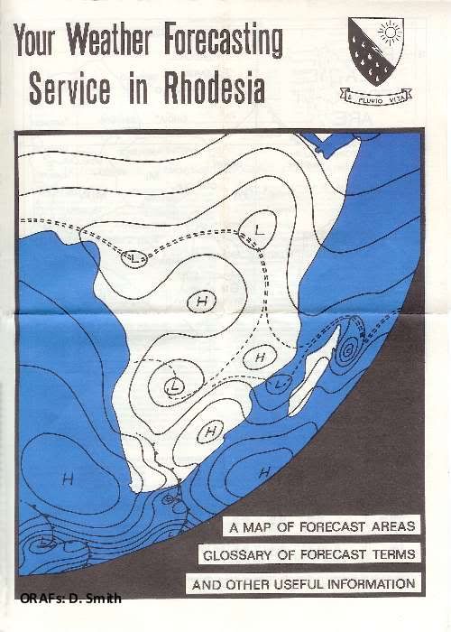
The Picture on the Cover. A rainy-season example of a synoptic hart representation of weather patterns which might be viewed from a space ship. A frontal system is moving across South Africa as the Atlantic anticyclone advances. A tropical cyclone has formed north east of Madagascar on the ITCZ. The Congo Air Boundary is near Rhodesia's north western border, and Congo Air itself covers the Congo and Zambia
Issued by:
THE DEPARTMENT OF METEOROLOGICAL SERVICES
Salisbury: August 1971
Printed by the Government Printer, Salisbury.
Re-compiled by Eddy Norris in February 2010
Documents made available to ORAFs by Diarmid Smith. Thank you Diarmid
CLOUD AND RAIN
Cloud development is especially associated with rising air. The reason is that air gets colder when it ascends, and the temperature may thus fall sufficiently for the invisible water vapour to condense and become visible in the form of cloud droplets. The rate at which unsaturated air cools as it rises is nearly 10°C per kilometre; when the air becomes saturated, the cooling rate due to ascent is reduced to about 5°C/km. If the temperature of the rising air becomes colder than 0°C, the water droplets start to freeze; the tops of tall clouds therefore contain many ice crystals. Drops of rain may develop either from the growth and coalescence of numerous cloud droplets, or from the action of ice crystals which serve as nuclei for raindrops.
There are various natural mechanisms whereby air is made to rise.
Air which is warmer than its surroundings, rises because it is less dense. This convection process occurs if pockets of air are sufficiently heated from below. Clouds produced by convection currents are therefore very common during a summer afternoon. Convection may at times be caused or strengthened by a decrease in temperature at higher levels of the atmosphere. The greater the temperature lapse rate, the more unstable the atmosphere is said to be. (On the other hand, a temperature inversion inhibits convection and represents a stable condition.)
Air is sometimes forced to rise over a range of hills or mountains. The ascent over windward slopes may produce what is known as orographic cloud and rain.
Convergence is caused by the flowing together of air streams from different directions. If this occurs near the surface, the excess air can only go up. An outbreak of rain and thunder conditions is thus frequently associated with converging air streams.
Another mechanism responsible for the lifting of air is associated with temperature discontinuities which often develop between air masses in middle latitudes. At a warm front the warmer air mass tends to slide up over the colder one; and at a cold front the colder air tends to undercut the warmer. In both cases, the ascent of the warm air is liable to produce cloud and rain. Active fronts of the cold variety occasionally break through to the tropics.
TYPICAL WEATHER PATTERNS ON RHODESIAN SYNOPTIC CHARTS
A "synoptic chart" is simply another name for a weather map. It is so called because it provides a synopsis (or general view) of weather conditions which prevailed at a specified time. The information plotted on a synoptic chart covers details of weather, cloud, temperature, humidity, pressure and wind—as recorded at a network of observing stations. Cloud photographs from weather satellites help considerably to complete the picture.
The weather analyst is principally concerned with locating the various highs, lows and fronts on his charts. The expected movements and developments of these pressure systems and air-mass boundaries form the basis of most of his weather predictions.
The belt of high pressure found in subtropical latitudes is known to be composed mainly of large, oval-shaped anticyclones, with troughs of relatively low pressure in-between; and these have a marked tendency to drift eastward. On the other hand, the cells of high pressure are inclined to linger over certain preferred localities. One of these favoured areas lies to the west of South Africa, where the "Atlantic Ocean Anticyclone" is a more or less permanent feature." And, during the colder months, there is a rather persistent continental anticyclone over South Africa.
From time to time the Atlantic anticyclone advances. Depending on a variety of circumstances, this may happen at intervals ranging from a couple of days to a week or two. Sometimes the anticyclone moves bodily eastward; more often than not, however, the advance produces only a "bud-off high". The eastward retreat of a continental or Indian-Ocean anticyclone results in falling pressure over most of South Africa; the wind tends to freshen from the north, and temperatures rise. Pressure then recovers with the advance of the Atlantic anticyclone (or bud-off high); the wind acquires a southerly component, and temperatures fall.
This is basically a very common sequence; and it may have significant effects on the weather, not only over South Africa, but over Rhodesia as well. In particular, when a high moves round the coast, its anticlockwise circulation often produces an invasion of cool moist air from the south-east. The overcast, drizzly or rainy conditions which are then liable to develop over windward slopes are known locally as "Guti" weather. And, if the air ahead is warm and moist, the temporary increase in convergence may well cause an intensification of rain and thunder conditions.
During the winter months, the anticyclone sometimes advances overland', very dry air is then liable to penetrate Rhodesia from between south and south-west, establishing conditions which are especially favourable for frost.
Convergence effects are inherently associated with the "Inter- Tropical Convergence Zone''' (or "ITCZ" for short). This is the belt along which the southern- and northern-hemisphere airstreams tend to meet. The ITCZ migrates back and forth across the equator as it follows the sun; on average, it extends over the northern half of Rhodesia during December, January and February. Its presence is in fact linked with our so-called "Main Rains".
"Congo Air" is the local name given to an air mass which is drawn in from the South Atlantic across Angola or the Congo during the warmer months. It occasionally reaches Rhodesia from the north-west as a very humid airstream. The "Congo Air Boundary" is, in effect, an appendage to the ITCZ.
Tropical cyclones of the South Indian Ocean also appear on our synoptic charts during the summer months. Their behaviour is extremely erratic. Winds of gale force commonly spiral clockwise towards the central vortex, and the resulting convergence may produce torrential rain within about 100 km of the centre. These tropical disturbances fortunately tend to weaken if they move inland. Interested persons will have noticed that, in each season, cyclones are assigned feminine code-names in alphabetical order.
The weather is of course three dimensional; so the forecaster must supplement his surface chart with various upper-level analysis. For example, it is the passage of an "upper cold wave" from the west or south-west that is mainly responsible for an unseasonal outbreak of rain or thunder in the dry months. And, during the rainy season, a persistent and extensive "upper high" is often to blame for a prolonged spell of dry weather.
These are some of the more common types of weather situation affecting Rhodesia. But synoptic patterns and sequences are infinite in their variety, and liable to tax the skill of even the most experienced of forecasters.
The Picture on the Cover. A rainy-season example of a synoptic hart representation of weather patterns which might be viewed from a space ship. A frontal system is moving across South Africa as the Atlantic anticyclone advances. A tropical cyclone has formed north east of Madagascar on the ITCZ. The Congo Air Boundary is near Rhodesia's north western border, and Congo Air itself covers the Congo and Zambia
Issued by:
THE DEPARTMENT OF METEOROLOGICAL SERVICES
Salisbury: August 1971
Printed by the Government Printer, Salisbury.
Re-compiled by Eddy Norris in February 2010
Documents made available to ORAFs by Diarmid Smith. Thank you Diarmid
Labels: Weather Forecasting
posted by Rhodesia Remembered @ 19:34
2 Comments
![]()
![]()


2 Comments:
Useful article. This is very cool when you writing about what you like. But when you need to write something like essay for topic you dont like only one way you have - ask some essay writing companies.
I Read your article. Thanks for sharing such beautiful information, and I hope you will share some more info about chauffeur service dubai . You wrote really very well, I really like your blog and information provided by you. I appreciate your work.
Post a Comment
Subscribe to Post Comments [Atom]
<< Home